

The Vuelta del Huemul Trek in 4 Days

Contents
Preparing for the trek: registration, equipment and food supplies
Registering with Los Glaciares National Park
Food supplies
Renting technical equipment
Day-by-day account: the Vuelta del Huemul, immersed in wild Patagonia
Day 1: Through valleys and woodland
Day 2: Views over the Southern Patagonian Ice Field
Day 3: Along the sea of ice
Day 4: An endless trail back to town
Tips for preparing for the trek
Difficulty level
Essential equipment
Campsites
Best time to go
Essential information before setting off
Route map
Eighty kilometres of hiking through Patagonia’s glacial landscapes… that was what awaited us on the Vuelta del Huemul trek.
A week earlier, I had arrived with my backpack in the small town of El Chaltén, an iconic starting point for treks in Argentine Patagonia. There, I met up with Mantas, a Lithuanian friend I had first crossed paths with a month earlier in the Amazon rainforest. After warming up on the trails to Laguna Torre and Laguna de los Tres, we decided to take on a more demanding adventure: the Vuelta del Huemul, a four-day route around the Huemul massif and deep into glacial wilderness.

Preparing for the trek: registration, equipment and food supplies in El Chaltén
Registering with Los Glaciares National Park
Before even setting foot on the Vuelta del Huemul trail, there are several essential steps to take to ensure your safety during the trek. We first had to visit the Los Glaciares National Park Visitor Centre, located at the entrance to El Chaltén. Registration is compulsory before beginning the trek, as the rangers keep a record of hikers for safety reasons.
We had to provide our route and planned departure and return dates. The rangers also gave us information about the weather forecast, trail conditions, the state of the zip lines and any active wildfires.
This is also a good opportunity to ask any practical questions you may have about drinking water, phone reception—which is almost non-existent along the route—seasonal recommendations and the designated camping areas. Registration is free but compulsory to enter this protected and remote part of the park.
Food supplies
We then stocked up in the grocery shops around town, which carry a fairly good selection of trekking food: noodles, rice, sauces, grated cheese, cereal bars, dried fruit and both sweet and savoury snacks. You need to carry enough food to be fully self-sufficient for four days, choosing meals that are easy to prepare and high in calories. There is nowhere to resupply along the trek.
You should also treat your water with purification tablets or a filter, even though there are plenty of streams. Livestock or hikers may occasionally be present upstream, so it is better to be cautious.
Renting technical equipment
Climbing equipment is essential for the technical sections, particularly the two zip-line crossings:
One climbing harness per group
Two or three carabiners
A 30–35 metre rope, essential if you need to send the pulley back to the other side
A pulley, which is generally already fitted to the zip line but may occasionally be missing
We rented the equipment from Bajo Zero, an outdoor shop in the north of El Chaltén, for ARS 2,000 per day in January 2023. The staff will show you which carabiner to attach to the pulley and how to secure yourself for the crossing. If there are two of you, one harness may be enough, as you can send it back to your partner after each crossing.
If you do not have your own camping gear, Bajo Zero also rents tents, sleeping bags and sleeping mats for around ARS 6,000 per day for the full set.
Day-by-day account: the Vuelta del Huemul, immersed in wild Patagonia
Day 1: Through valleys and woodland
Distance: 21 km | Elevation gain: 800 m | Elevation loss: 450 m | Duration: approx. 7 hours | Difficulty: 1/5

We leave El Chaltén in the cool morning air, eager to get moving despite our heavy backpacks. During the first few kilometres, the trail climbs gently through a forest of lenga trees, the gnarled Patagonian beeches with their silvery trunks. The silence is broken only by rustling leaves and distant birdsong. We settle into a relaxed pace, perfect for absorbing our surroundings and warming up our legs.

After a few hours, the vegetation gradually thins out and we enter a wide glacial valley dominated by rock walls and crossed by a winding river. This is where the first river crossings begin. We have to wade through several channels, some shallow and others reaching our knees. The rocks are slippery, the current can be fast and the water is quite literally freezing.

👣 A tip from the trail: A pair of sandals can be a lifesaver when crossing rivers. The water is icy and the rocks are often slippery. A microfibre towel is also useful for drying yourself quickly after each crossing. |
We reach the Laguna Toro campsite in the late afternoon, beside a large lake surrounded by mountains. It is a peaceful place to rest and watch the changing colours of the Patagonian sky at the end of the day. The lake water is crystal clear, and a nearby spring provides somewhere to refill our bottles.
Day 2: Zip line and views over the Southern Patagonian Ice Field
Distance: 16 km | Elevation gain: 800 m | Elevation loss: 400 m | Duration: approx. 7 hours | Difficulty: 4/5
After making our way around the lake, we reach the first zip line. Suspended above a raging river, the crossing is tense and silent, and every movement matters.

The wind is blowing fiercely and the power of the current below is intimidating. I put on my harness, clip my carabiners to the pulley and the cable, and launch myself above the void, my heart pounding. I pull myself across using the strength of my arms until I reach the cliff on the opposite bank. Throughout the crossing, I keep my eyes fixed above me so I am not overwhelmed by the rushing river below.
🧗 How to cross the zip line safely: Before setting off, make sure the pulley is positioned correctly on the cable and that both carabiners are properly secured: one should connect your harness to the pulley and the other directly to the cable. If you transport your backpack separately—which is strongly recommended—attach it firmly to the pulley with a knot that you know how to release quickly. ⚠️ Avoid looking down during the crossing. Focus on the horizon or the cable, especially if the current below makes you nervous. If you are hiking as a pair, one harness is sufficient, but allow a good hour for all the back-and-forth movements. Hikers often help one another here, and there is usually a real sense of solidarity. |
After the crossing, we spend the entire morning scrambling up unstable scree while battling unpredictable gusts that catch us off guard and knock us off balance. We regularly have to stop and press ourselves against the ground until the most dangerous blasts of wind have passed.

But before long, the vast glacial landscape unfolding ahead of us drives every doubt away: the Southern Patagonian Ice Field is finally there, in all its majesty.


The climb towards Paso del Viento is tough, but when we finally cross the pass in the early evening, the reward is immense: a dizzying panorama over the Southern Patagonian Ice Field, the third-largest continental ice field in the world.


One thing is certain: Paso del Viento—the Windy Pass—lives up to its name. After spending the entire day fighting powerful gusts, we stand at the top, alone in the world, facing an endless sea of ice. Words fail me as I try to describe that moment.
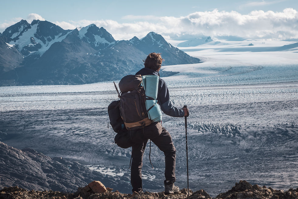


Leaving the pass behind, we descend for another five kilometres until we reach the Paso del Viento campsite beside a stream. Our second day of hiking ends in the final rays of sunlight, our bodies exhausted but our minds filled with wonder.
Day 3: Along the sea of ice
Distance: 19 km | Elevation gain: 500 m | Elevation loss: 800 m | Duration: approx. 9 hours | Difficulty: 4/5
The sound of raindrops hitting the tent wakes us at dawn. Warm inside our sleeping bags, we decide to go back to sleep and hope that the sun will appear a little later. The gamble pays off, and we set off beneath clear skies at around 9 a.m. Throughout the morning, we walk alongside the ice field stretching as far as the eye can see.


During the afternoon, the trail climbs increasingly high above the glacier until we reach Paso Huemul. The wind hits us with such force that it is impossible to remain at the pass long enough to enjoy the view.

We begin the descent on the other side of the mountain, where a sweeping view of Lake Viedma opens up before us. The lake is fed by the same sea of ice we have been following until now.
Almost immediately, the smell of burning catches my attention. My first instinct is to remove my backpack and check that my stove has not caught fire. It has not—but the smell persists, and the colour of the sky begins to change. Darker, increasingly opaque clouds gather above us. I start to worry, and we quicken our pace.
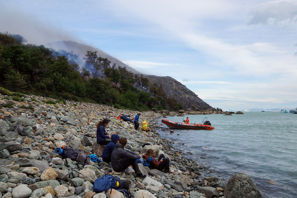
Eventually, we reach a viewpoint from which we can see a wildfire spreading around the Bahía Témpanos campsite, our destination for the night. The campsite lies on the shore of Lake Viedma, where enormous icebergs calved from the glacier float on the water. Fire burning right beside the ice—the irony is striking.
A ranger eventually reaches us to explain the situation and give us instructions. Despite the fire, we must continue towards the campsite to reach an area secured by the firefighters.

The smoke makes breathing unpleasant, and the descent is also extremely steep and slippery. After several hours, we finally reach Bahía Témpanos, with flames spreading around the camping area. As night falls, the firefighters settle us on the shore of Lake Viedma, just metres away from gigantic icebergs. That night, we sleep beneath the open sky, ready to evacuate if necessary.

Day 4: An endless trail back to town
Distance: 27 km | Elevation gain: 600 m | Elevation loss: 400 m | Duration: approx. 10 hours | Difficulty: 1/5
By morning, the flames are under control, and we wake beside icebergs floating on the blue waters of Lake Viedma—a magical moment. We start walking again, following the lakeshore for hours with stiff, aching muscles. The wind is gentler now, and the snowy summits in the distance remind us of everything we have just crossed.


At 27 kilometres, this final stage is extremely long, although the trail is mostly flat. From the first few kilometres, however, we are treated to a beautiful panorama over the beginning of the ice field.

We arrive back in El Chaltén at around 8:30 p.m. and head straight for the first restaurant serving a proper Argentine parrilla!
The Vuelta del Huemul will undoubtedly remain one of the most memorable treks of my life as a traveller. Between the intense physical effort, complete immersion in the Patagonian wilderness, technical sections and unexpected events, every day taught us humility in the face of these immense glaciers and mountains. If you are looking for a demanding and authentic adventure in the heart of Patagonia, this trek is for you.
Tips for preparing for the Vuelta del Huemul trek
Difficulty level
I recommend this trek for experienced hikers who know how to navigate with a map and are comfortable crossing rivers both on foot and by zip line. The daily stages can feel long, particularly because it is difficult not to stop regularly and admire the scenery. We generally left at around 9 a.m. and reached the next campsite at about 9 p.m. The wind caused us serious difficulties, especially while crossing the mountain passes, so make sure you check the forecast carefully before leaving.
Essential equipment
🧗 A pair of carabiners
🪢 One harness and a 35-metre rope per group. A single harness is enough for two people, as you can send it back to your partner with the pulley after crossing the river.
⛺ Camping equipment: tent, sleeping bag and sleeping mat
🔥 Camping stove, cookware and cutlery
🥫 Food for four days
🧽 Water-purification tablets or a filter. Even if the rivers look clean, it is safer to treat the water, especially at lower elevations.
🥄 A small sponge or cloth to wipe down the tent or dry your belongings quickly
♻️ A rubbish bag so you can carry all your waste back with you
🌧️ Waterproof jacket and trousers
🧤 Hat, gloves and neck warmer. Even in summer, temperatures can drop suddenly, particularly at night and around the mountain passes.
🧦 Spare socks and dry clothes for the night or in case of unexpected conditions
🥾 Trekking poles. I found them particularly useful for river crossings, keeping my balance in the wind and tackling the steep descent on Day 3.
🩴 Sandals for crossing rivers
🧴 Sunscreen
🧼 A minimal toiletry kit: toothbrush, toothpaste, toilet paper or biodegradable paper
🩹 First-aid kit: plasters, disinfectant, basic medication such as painkillers and anti-diarrhoeal tablets, and sports tape for sprains
🗺️ A digital and/or paper topographic map. You can use an offline mapping app such as AllTrails, provided you download the maps in advance. Carrying a compass as backup is always a good idea.
🔋 Power bank
🔦 Headtorch and spare batteries for evenings at camp
🧵 Repair kit: thread, a needle, duct tape or reinforced tape for fixing a backpack, tent or other equipment
🧗 Renting equipment in El Chaltén: Head to Bajo Zero, a specialist mountain shop in the north of El Chaltén. The staff regularly equip hikers for technical treks and can explain how to use the zip lines, including how to position the pulley and attach your carabiners. Indicative prices:
👉 Tip: Try on your harness before setting off and ask the staff to demonstrate how to position the carabiners and pulley on the zip lines. |
Campsites
Wild camping is prohibited in Los Glaciares National Park in order to protect the natural environment. However, free designated camping areas have been established for hikers and divide the trek into four stages. They are always located near a stream or spring, and some also have dry toilets or a small cooking shelter.
Laguna Toro campsite
Paso del Viento campsite
Bahía Témpanos campsite
Best time to do the trek
The austral summer, from December to February, is the most favourable time for hiking in Patagonia. Temperatures remain cool, but the days are long and weather conditions are generally more stable.
Before setting off: compulsory registration
Where? At the Ceferino Fonzo Visitor Centre in El Chaltén, which is open every day.
How? In person or through the online Mountain Activities Register (Registro de Uso de Montaña).
Why? To keep hikers safe, record your route and provide you with essential information about the weather, trail conditions and safety.
Who must register? Anyone entering remote areas on routes such as the Vuelta del Huemul, Paso del Viento or Paso del Cuadrado. Registration is not required for the classic trails closer to town.
Topographic route map
You can find a detailed GPS track of the Vuelta del Huemul here, including its main landmarks, elevation profile, campsites and zip lines. It is a valuable resource to consult before setting off or to use offline during the trek: https://www.wikiloc.com/hiking-trails/vuelta-al-huemul-10777530

Prepare carefully, respect the natural environment, help your fellow hikers—and let yourself be overwhelmed by the raw beauty of this extraordinary corner of the world!


Comments